Scientists have long understood that rivers and lakes influence one another, but actually observing where one system gradually transitions into the other has remained a challenge — until now.
A new study led by researchers in the department of Geography and Geographic Information Science at the University of Illinois Urbana-Champaign, including professor Jida Wang and postdoctoral researcher Xinchen He, and professor Bruce Rhoads, in collaboration with researchers from multiple institutions, is exploring these long theorized processes.
The work builds on a broader NASA-funded project led by Wang, who serves as the department’s principal investigator, using data from NASA’s Surface Water and Ocean Topography (SWOT) mission to directly observe how rivers and lakes interact over large distances and under changing conditions. The research introduces the concept of the lake-river continuum (LARIC) and, for the first time, demonstrates how satellite observations can track these dynamic transition zones in real-world systems.
Bringing the laboratory into the real world
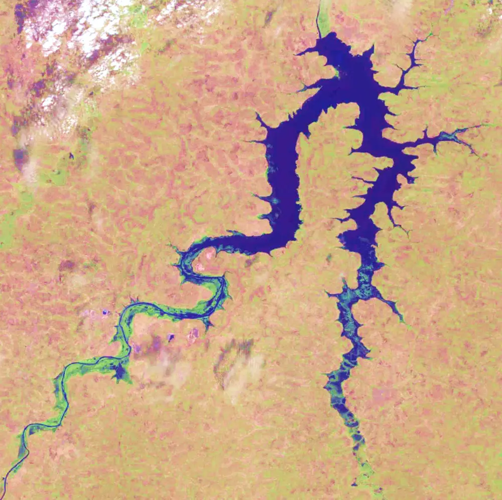
When a river flows into a lake or reservoir, the calmer water downstream slows the river’s flow and raises upstream water levels, a phenomenon known as the backwater effect. This creates a transition zone where river and lake conditions gradually blend rather than changing abruptly.
Scientists have long studied these interactions in laboratory experiments and computer simulations, but observing them continuously in natural systems has been difficult.
“We learned about this transition in an open-channel hydraulic textbook,” said He. “We’ve been able to recreate it in laboratory experiments and computer models for years, but it’s kind of impossible to observe in the real world. Because imagine if you want to take an observation in the field, you can only do so at one site at a time, but we need continuous measurements over hundreds of kilometers.”
Traditional methods could not capture water-surface changes continuously over long distances. SWOT changed that.
“Using SWOT, we can move the laboratory into the real world and observe continuously,” He said.
Launched by NASA and the French Space Agency CNES in December 2022, SWOT is the first satellite capable of simultaneously measuring water-surface elevation and surface area at high spatial resolution across rivers, lakes, and estuaries.
“SWOT is the first-ever spaceborne wide-swath altimeter capable of measuring spatially continuous water-surface elevation and surface area,” said Wang. “The capacity for synchronous, simultaneous measurements of both area and elevation enables us actually to observe two-dimensional surface hydrodynamics.”
A moving and invisible boundary
The researchers describe the lake-river continuum as a gradual and dynamic transition between flowing river systems and more stagnant lake conditions.
“Lakes and rivers are mutually affected,” He said. “They are not two separate functional units.”
Rather than a clear dividing line, the transition can extend over tens of kilometers and shift over time in response to floods, droughts, and reservoir operations.
“When people say lake-river interface, they often imagine a clear-cut or fixed point,” Wang said. “But our work actually quantified that it is both zonal and dynamic. Its position can vary by more than 100 kilometers.”
The study found that the transition zones themselves can stretch from 10 to 75 kilometers in some reservoirs. At the same time, their positions can shift more dramatically throughout the year as changing inflows and reservoir management jointly alter water levels.
The researchers say understanding those transitions is important because they influence sediment transport, ecosystems, and floodplain dynamics.
“When the river slows, the sediment it carries tends to deposit,” He said. “So where it slows down, that’s where sediment might start building into a delta.”
Wang said the findings also reveal that rivers may already be slowing and changing before the visible portion of a lake begins.
“The visible portion is that you look at an image and say, ‘Oh, this place becomes wider — that must be the start of the lake,’” Wang said. “But before that, the water may already be slowing down, and sediment may already be starting to deposit.”
“Understanding how the flow of rivers and the associated deposition of sediment changes as lake levels change is especially important for reservoir management,” says Rhoads. “Over time, reservoirs fill with sediment, and this work will help to advance knowledge of how that process varies in space and time.”
A new perspective on global water systems
The project brought together researchers from multiple institutions, including Virginia Tech, Texas A&M University, the University of Bristol, and CNES, combining expertise in lake, river, and geomorphology sciences.
“One of our goals is to bridge the fields of river and lake sciences,” Wang said. “Lake and river science are often studied separately, but they are essentially integrated systems.”
The researchers say SWOT’s ability to observe water systems worldwide continuously could reshape how hydrologists study reservoirs, rivers, and freshwater systems in the coming years.
“If we open Google Maps and turn on satellite mode, what we can see is different colors of rivers,” He said. “But with SWOT, you can think about improving it to another dimension, and it tells you how high the water surface is.”
The team plans to expand the work from several reservoir systems to a global scale, studying how lake-river transitions behave in systems around the world.
“We want to expand from several reservoirs to thousands of lake-river systems,” He said. “SWOT is a global mission, so it gives us the opportunity to study these dynamics worldwide.”