Our department recently launched GEOG 392 - Geography & GIS Internship, an undergraduate course that awards academic credit to students who participate in off-campus internships. Steven Chang, a senior double-majoring in Geography & GIS and Geology, wrote the following report to share his experience as a Summer 2017 intern with the Metro-North Railroad Company in New York City.
 For the past two months, and continuing through mid-late August, I have been interning at Metro-North Railroad Company, a subsidiary of the Metropolitan Transportation Authority (MTA) based in New York City. The MTA is a public benefit corporation that provides public transit services in the New York Metropolitan Area, covering the city itself and various surrounding geographic areas, including Long Island and extending into southwest Connecticut. Metro-North Railroad is a branch of the MTA that provides commuter rail service to areas north of the city, and northwest into Connecticut. Based in the historic Grand Central Terminal, Metro-North Railroad operates 3 commuter lines east of the Hudson River, and 2 lines west of the Hudson. Together, these commuter rail lines link the surrounding areas and the city of New Haven in Connecticut with New York City, providing convenient and reliable rail transit options for over 86 million riders in 2016 alone. Over the course of this summer, I spent most my time working in the main office of Metro-North, in an office building that sits right next to Grand Central and connected to the station via a tunnel walkway. Occasionally, I am summoned to the headquarters of the MTA, situated in Lower Manhattan, for real estate tasks that I will soon describe.
The official position that I hold for the summer is GIS Intern, within the Metro-North (MN) Department of Capital Planning and Programming. I am part of a team within the department mainly specializing in GIS data for the railroad. The main tasks of our group are to acquire, clean, process, and present GIS data in the form of maps and web applications, complete with labelled features and related attributes. These data and map productions are then passed on to other departments, including but not limited to safety, operations, and long-range planning, for use and applications in a wide variety of tasks and purposes. Various departments use our GIS data as a foundation upon which they carry out their work.
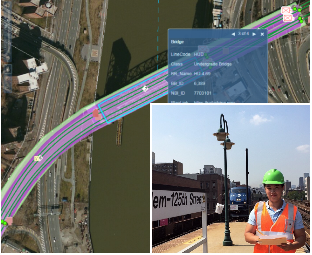
Throughout my time at Metro-North, I have been focusing on three main tasks. The first one is the digitizing of bridges on all the train lines that form a crucial part of the Metro-North infrastructure. An interactive database called Railadvise has been created earlier that contains locations and attributes of bridges currently in service, along with crucial inspection statuses and archived inspection reports. My task is to compare the Metro-North EGIS system to Railadvise and add the missing bridge features by using the Editor, and key in attributes related to each feature (bridge). These attributes include line abbreviations, mileposts, and unique bridge identifier numbers. Some bridges have already been created in the map document that I am working on, and when I encounter those, I perform quality check and ensure all information is accurate and up to date. The overall process links the Metro-North EGIS system with the inspection database system, providing Metro-North employees easy access of critical data for any bridge within the railroad network.
The second task involves creating a log of all street access to the Right-of-Way (ROW). The objective of this log is to inform service workers and departments that may be performing field work of all official access points to the ROW, as a lot of unofficial access points currently exist, and there is a lack of a unified inventory of all official and authorized access points. I utilized satellite imagery from Google to locate all the access points from an aerial point of view, and record all access points along with related attributes such as mileposts, latitude, longitude, type of security, and more, in an Excel spreadsheet. My contribution to this project represents a first pass to the creation of a log that has never been done before, and by relying solely on satellite imagery, I generated a broad overview of where most of the access points are located. The spreadsheet is then sent to other departments for quality check, and for field evaluation to ensure these access points are in serviceable order. More gates and access points may also be located from field visits.
The third, and perhaps the biggest project that I am involved in this summer, is to assist consultants in creating GIS data of all Metro-North owned property and land parcels. This project involves creating a database of all Metro-North property, along with all associated legal documents. The benefit of having this system is that it takes into consideration parcel and property ownership, and may streamline future infrastructure expansion and design by avoiding potential legal issues and conflicts of interests. This project involves sifting through vast amounts of real estate data, sales deeds, easement agreements, court orders, and various legal binding documents. Because Metro-North must go through MTA Real Estate to acquire property, these legal documents are only accessible through the MTA. For this reason, when I worked on this project, I report to work at the MTA Headquarters in Lower Manhattan. Legal documents, complete with maps and parcel descriptions for all property acquisitions from within the past 50 years are uncovered and forwarded to a partner company that will be responsible for interpreting these data and geocoding the descriptions into maps. Although I am not directly involved in actually creating the maps, my contributions serve as a basis in which the soon-to-be created maps will be based on, and through these maps Metro-North will have a better count of all its properties, which may be beneficial when expansions and addition of hardware infrastructure may be necessary to improve service or increase capacity.
This internship opportunity at Metro-North enables me to gain valuable hands-on experience in the GIS field, and to better understand the subject along with its areas of application. Prior to this internship, the only experience I have had with GIS is through class assignments and short projects, and this internship is a great opportunity for me to apply that knowledge in a corporate environment. Although I have not planned out a solid future career path yet, my general focus would be mapping, spatial data analysis, information technology, and perhaps even data science. The experience I gained through the internship is an overview of what I can expect working with geographic data in my future career. One important thing I learned is how to function and bear responsibilities in a corporate environment, as the maps and documents I create are passed on to other departments and will serve as foundations upon which various other work and tasks are to be performed, and thus there is a certain expectation for my work, and the data needs to be up to a certain standard. Overall, this summer is a valuable experience that makes my GIS exposure more complete.