
How did you decide to become a geographer?
I started off as an environmental science major at Wuhan University in China. During my first year, I took electives in programming and discovered how much I enjoyed it. GIS was our sister program at the time and I learned that many GIS faculty members were using programming in their work, and applying it to study critical social and environmental issues. I was drawn to this intersection of technology and real-world impact and decided later that year to switch to GIS and pursue a path as a quantitative geographer.
What is your most memorable field research experience or discovery so far?
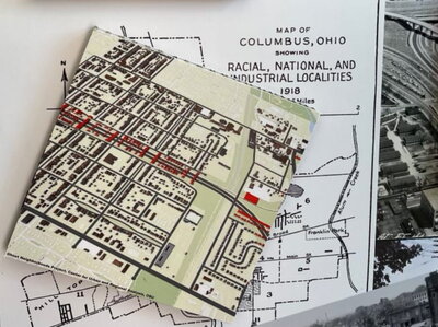
During my PhD studies, I was a research assistant. fora project entitled 'Undesign the Redline' that used machine learning to digitally reconstruct Hanford Village, a historical Black neighborhood in Columbus, Ohio that was leveled in the 1960s for highway construction. It was a memorable experience to visit the present-day site while working to visualize its past as a vibrant community filled with homes, businesses, and culture. I later brought this methodology to Chicago, where I taught students how to explore historical maps in local and university libraries and museums and use machine learning to recover what Hyde Park and other neighborhoods looked like before the sweeping changes of urban renewal in the city.
What are your current research interests and directions?
My research explores the intersection of data, computation, and human values. I am interested in how emerging geospatial technologies can be designed and used in ways that are ethical, socially responsible, and beneficial to humanity. More broadly, my interests span spatial data science, location privacy, and the societal implications of algorithmic systems. I’m currently investigating the social implications of geospatial artificial intelligence, including issues of social bias, semantic collapse, and loss of diversity. I’m also committed to helping students to engage critically with these technologies by integrating AI literacy and ethical reasoning into their geospatial education.