How did you decide to become a geographer?
I am a physical geographer interested in the hydrosphere and its interactions with human societies. Like many others, my academic trajectory was non-linear. The path to becoming a geographer involved years of multidisciplinary training, introspection, and exploration with a core passion for understanding diverse natural environments and their roles as both habitats and resources for humans. I started with a bachelor’s degree in environmental economics and management, then a master’s degree in environmental and resource engineering. Through these trainings, I also became increasingly fascinated by rapidly advancing Earth-observing satellite systems and their potential for addressing large-scale environmental issues. As my analytical skills sharpened, I began to seek a more integrated, inclusive, and multi-scale platform that allowed my interests to converge ., and geography was such a discipline. So, I decided to pursue a Ph.D. and have gradually matured into a geographer.
What is your most memorable field research experience?
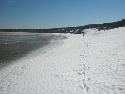
During the summer of 2010, I joined a one-month NSF-funded field campaign to study thermokarst lakes in the Alaska North Slope. At that time, I was a second-year Ph.D. student struggling to map thaw lake basins using radar imagery. Although I had dwelled in the remote sensing lab for months, my perception of thermokarst remained fuzzy and abstract. On the way to the campaign site, our airplane crossed the beautiful Brooks Range and started to descend to Utqiagvik, the northernmost human settlement in the United States. Thousands of ice-covered (in June!) thermokarst lake
s appeared on the horizon across the vast stretch of the Arctic Coastal Plain and I began to grasp the true scale of thermokarst landscapes and their immeasurable significance to the carbon cycle. During the following weeks, I worked with the science crew to investigate thaw lake shorelines, bathymetry, and other geomorphic and thermal controls. Despite the strenuous physical fieldwork, the joy of curiosity kept me motivated and happy every day. Being able to study this complex and dynamic landscape in situ was an incredible enlightenment unparallel to any lab experiments. Besides fieldwork achievements, this experience left me with many adventurous memories and unique cultural enrichments. My encounter with two grizzly bears in the wilderness was just one example. During our campaign in Atqasuk, an Inuit village 60 miles south to Utqiagvik, I also made friends with a few local kids and had an initial engagement with the indigenous lifestyle, language, and culture.
What are your current research interests and directions?
My current research niche is surface water dynamics, particularly in lentic (i.e., slowly moving or hydrologically stationary) ecosystems including lakes, reservoirs, and wetlands. These physical components store the greatest mass of liquid freshwater on Earth and sequester a disproportional amount of organic and inorganic carbon. I study how these water stores function as “sentinels, regulators, and integrators” of climate change, and how lakes of different types interact with the fluvial systems, the cryosphere, the carbon cycle, and human-water managements. I conduct such studies through multi-sensor satellite remote sensing, in situ measurements, hydrological modeling, and machine learning. I am also a member of the current science team of the Surface Water and Ocean Topography satellite mission. I work with my collaborators to improve prior hydrological data and leverage the roles of lakes and reservoirs to assist in river discharge estimation. Meanwhile, I am constantly engaged in research projects that aim at improving the representation of human water managements in terrestrial hydrology, the monitoring of lake water budget and quality, and the understanding of fluvial-lacustrine continuum.