How did you decide to become a geographer?
I began my undergraduate studies here at UIUC with an interest in environmental sciences but switched to geology after taking several of their field courses. I first learned about GIS on the job as a student research assistant with the Illinois Geological Survey on campus, and really enjoyed the challenges of analyzing core samples from Southern Illinois and using SQL to wrangle all the different layers of data.
I’ve always been interested in how humans relate with the environment, though, which became clearer on a study abroad trip to the Galapagos Islands. The landscape of volcanic rocks became overshadowed by the plight of locals being negatively impacted by both regulations and tourism in complex, intersecting ways. Still, I pursued a career as a geologist, and went on to intern at the United States Geological Survey in St. Petersburg, Florida. There, in addition to picking microfossils for climate change research and later using GIS to map coastal areas, I worked on multiple community and science education events. I was alarmed at the discord and mixed communications between scientists and community members on issues ranging from fishing quotas to hurricane impacts and decided to improve my own communication skills by getting a MFA in writing, with the goal of improving understanding of science between various communities.
Of course, things took another turn, and the introduction of critical theories in my writing degree shifted my views further. I began to engage my interest in community development with coding and communications, eventually serving as a city community engagement coordinator at the newly developed Institute for Public Health & Medicine at Northwestern University. I learned from the communities I worked with and identified research gaps in emerging views of public health that required new analytical approaches.
Here my GIS skills returned in high demand, as place is crucial to understanding health, and I found a home to integrate my interests. I learned to code, went to civic tech meetups, and joined hackathons. I pursued an online masters in GIS to further hone my GIScience skills and eventually moved across the country to start my PhD in geography after many nights spent reading academic articles “for fun.” Geography integrated my interests and sense of urgency across humans, environments, and modern analytics in the most insightful way, unafraid of bending beyond the boundaries. Public health needs more geography to engage in the complex, intersecting problems we face as a human society.
What is your most memorable field research experience?
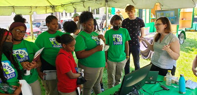
My team from the UChicago Center for Spatial Data Science Research participated in Green City Day at the DuSable Museum for African American History this past summer, where we shared ChiVes, our newly released free and interactive web mapping application on environmental and social justice indicators, with the South Side community. We had added live air quality summaries from Microsoft research sensors in Chicago, and integrated data streams from multiple partners in the area. I was able to finally meet collaborators and community leaders in person to talk about the challenges ahead, improve the work we were already doing, demonstrate the work to visiting student groups, and make new connections in the fight for a more just future.
What are your current research interests and directions?
My research at the Healthy Regions & Policies Lab centers on how “place” influences health outcomes in different ways for different people. I hope to better understand how structural inequality might be perpetuating social and environmental health disparities, and then develop GIS applications to communicate those results. I lead the U.S. Covid Atlas, a county-level exploration of the pandemic and social factors across time that will soon include oral histories to integrate the lived experience of COVID-19. I also have multiple projects evaluating how access to medications for opioid use disorder impacts lives over time, exploring the impacts of stigma and identifying potential intervention spots. Finally, my research will continue developing customized tools to empower communities to engage in exploratory spatial data analysis for evidence-based advocacy and policy support related to environmental justice.