The Eastern Illinois Foodbank (EIF) has been distributing food to those in need for over 30 years, a mission that requires great organization, many devoted volunteers, and an excellent sense of Illinois geography.
In July 2015, the Foodbank expanded its service area to include DeWitt, Livingston, and McLean counties, representing an increase of about 6,000 square miles, in which almost 30,000 food insecure families and individuals live. Kristen Costello, EIF’s Development Relations Manager, approached our department for help creating a map of the expanded service area, which now encompasses 17 counties.
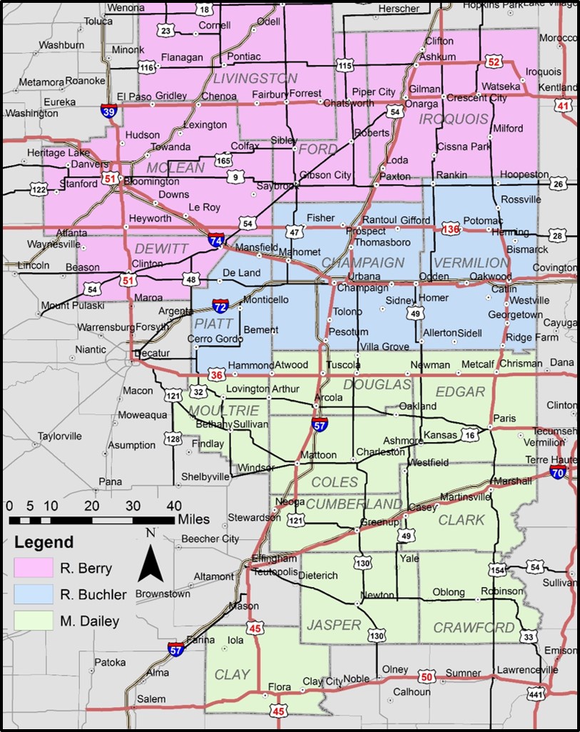
“We were in need of an updated service area map to help us geographically identify areas of need, proximity between existing agencies (EIF member food pantries, soup kitchens and shelters) and food sources such as grocery stores, and essentially help us strategize how to best address the need in our newly acquired counties,” said Costello.
Quinn Lewis, a Geography & GIScience Ph.D. candidate, volunteered to help the Foodbank with this new map. Lewis’s research focuses on flow and sediment mixing at river and stream confluences, so mapping county boundaries and highways was a slight, though enlightening departure.
“Creating this map was an interesting change of pace from the geomorphic mapping I commonly do. It was fun to work with a few basic instructions, yet have the freedom to make decisions about how to display the data,” said Lewis. “Making this map reminded me to always have the audience in mind, which is not often something I think about when making topographic maps or plotting the locations of ground control points.”
Once Costello and Lewis finalized the map, the Foodbank printed a poster-sized version for the wall of their Urbana headquarters, and Costello and other staff members keep printed copies at their desks.
“Our work with the department is a great example of skills based volunteering,” said Costello. “The Foodbank relies heavily on the support of our community and the University of Illinois is a great resource of volunteers. The Department of Geography & GIScience was able to help us by providing these valuable maps that enable to us to effectively target food insecurity in eastern Illinois,” said Costello.