Analysis of aerial photography to determine stream channelization over time
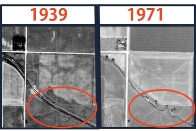
I worked with Professor Bruce Rhoads to analyze the impact of channelizing streams over time. Our study looked at the Big Pine Creek Ditch in Benton County, Indiana, which required collecting aerial photography of the river from every decade available. Through the course of this project, I learned how to navigate aerial photography indices and locate the proper archive which will be helpful as I take on future coursework and projects.
One of the biggest challenges of this project was to determine the river’s centerpath. Vegetation blocked portions of the river during certain years, so we had to utilize multiple years of imagery in those cases where a single image or even its stereopair were not enough to trace the path. This aerial photography study has enhanced my interest in the field, and I can see myself pursuing it further. It truly has been a wonderful experience and I am thankful to be a Roepke Scholarship recipient!